Indian Petroglyphs Dry Fork Canyon
These Native American petroglyphs are world-renowned, found all along 200-foot-high “Navajo Formation” sandstone cliffs. The tour can take from 1 to 8 hours, depending on how far you want to go and how much you want to see. The petroglyphs are on private land. Contributions are accepted; all that is asked is for visitors to obey all signs and not damage the sites. Nowhere else can you see more petroglyphs in one area that are so easily accessible. There are trails that take you up close and personal to view figures up to 9 feet tall. These figures represent the Fremont culture, which flourished in this area from about 1-1200 A.D. Besides petroglyphs and breathtaking views, you may also want to visit the Jean McConkie McKenzie house just to the right of the parking lot. If there is someone at home, they will show you many Native American artifacts, a replica of an old-time saloon, an antique-filled house, and a general store which were constructed on a ridge that was, at one time, a huge Native American winter camp. The parking lot for the petroglyphs and the historic sites mentioned above is located 3/4 of a mile off the main canyon road and is accessible year-round. This is one tour you will always remember!!

Mileage
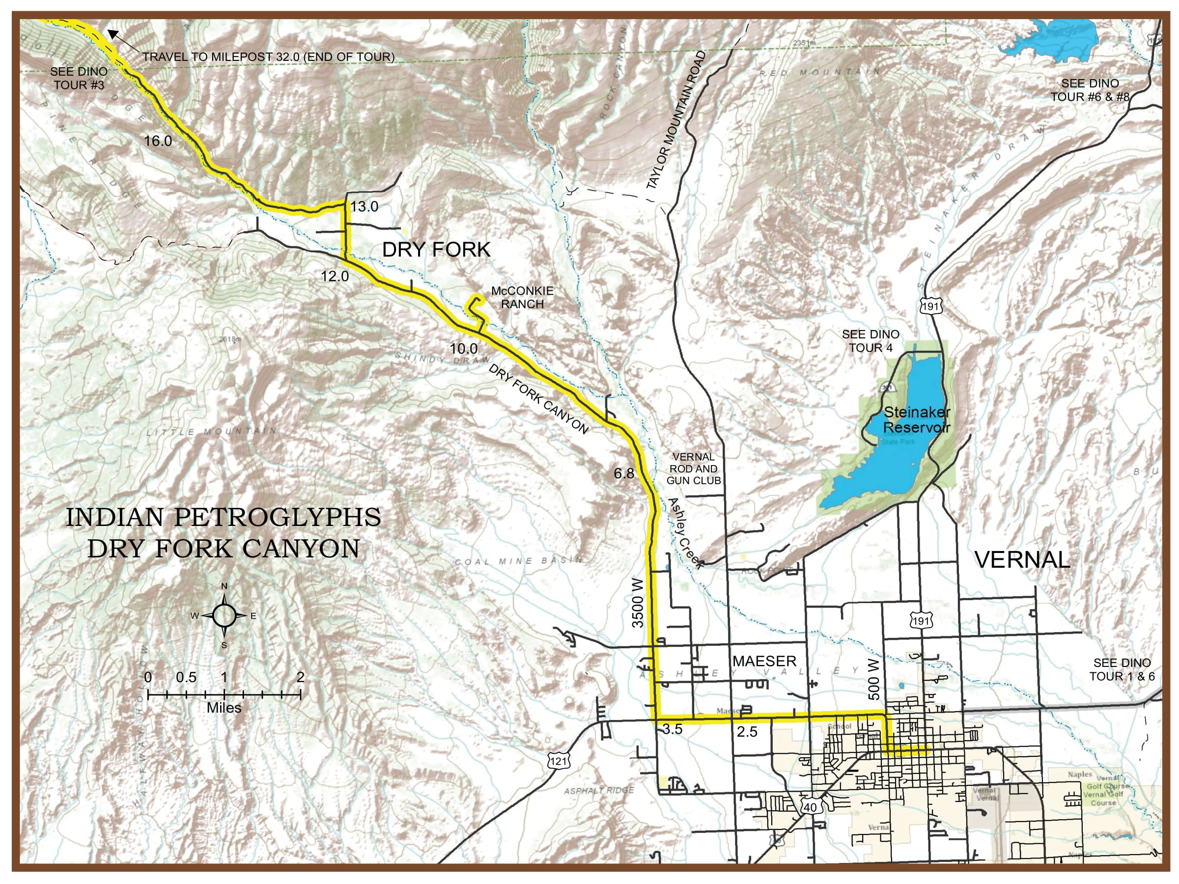
0 Leave Vernal north at 500 West and Main–Highway U-121
2.5 Maeser Town.
3.5 Turn north (right) to Dry Fork Canyon (3500 West).
6.8 “Remember the Maine.” Stop here at the turnout where you can see this 75-year-old, hand-painted American flag and “Remember the Maine” high on the vertical sandstone cliff. The original “Remember the Maine” painting was done in 1898 in memory of the many Americans who were injured or died in the blowing up of the American battleship, The Maine, in the Havana Harbor.
10.0 Native American Petroglyphs-turn right into Sadie McConkie Ranch. Follow directions to the parking area. The sandstone cliffs here are literally covered with artwork done by Native Americans of an earlier period. This is a concentration of some of the best and most easily accessible Native American art to be found anywhere.
12.0 Junction-tour turns right (left to Deep Creek).
13.0 Dry Fork Village-the location of one of the early settlements in Ashley Valley (no markers).
16.0 Lower Dry Fork Canyon-beautiful, shaded picnic sites for your use along this route for several miles before you begin the climb to higher elevation. This tour returns to Vernal from here. However, if you wish to continue into the “High Uinta Mountains,” see Red Cloud Loop Tour #3. End of tour milepost 32.0.
