Diamond Mountain Jones Hole & Fish Hatchery
A visit to the Hatchery and nearby hiking trails in the adjacent canyon will make any day special. The hatchery provides four different species of trout for stocking in local waters. Brook, brown, cutthroat and rainbow trout are all raised at the facility. Visitors are invited to walk among the 50 outside raceways where the fish are kept before stocking and to visit the main Hatchery building where there is a fish-rearing area, egg-incubation units and displays telling the story of how the fish are raised. After visiting the hatchery, walk down to Jones Hole following Jones Creek down the canyon. This is a wonderful four-mile trail that is part of Dinosaur National Monument. You will be able to view Fremont Indian pictographs, lush streamside vegetation and spectacular rock walls rising hundreds of feet above the canyon floor. There is also an abundance of wildlife for viewing for those who are quiet and careful observers. At the end of the trail, Jones Creek meets the Green River. There are picnic tables available at the river’s edge for day use, or just to sit and rest until you are ready to walk back up the canyon.

Mileage (Paved road, driving time-3 1/2 hours round trip)
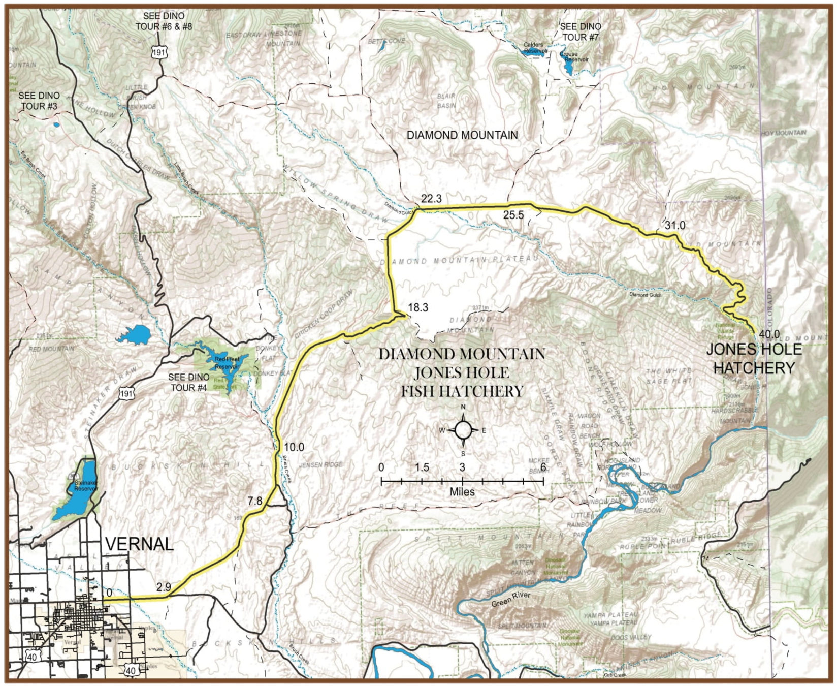
0 Leaves Vernal going east on 500 North from Vernal Avenue (see map) and takes you over famous Diamond Mountain (see story) to Jones Hole National Fish Hatchery on Jones Hole Creek-a crystal clear stream that emerges from a single underground source and runs only
3 1/2 miles before emptying into the Green River inside Dinosaur National Monument.
2.9 Junction-take left road. You are leaving Ashley Valley; the next five miles take you over a bench where you will see diverse plant life that has adapted to its area.
7.8 Junction-continue straight ahead. (The road to the right goes to Island Park and Rainbow Park in Dinosaur National Monument)
10.0 Brush Creek Junction-this is the low point on the tour, 5,300 feet, and you now begin an 8-mile climb to the rim of Diamond Mountain Plateau.
18.3 Junction-take left road (right follows rim to dead end). The rim is just under 8,000 feet in elevation. You have climbed about 2,600 feet since leaving Brush Creek. The Diamond Mountain Plateau is partly privately owned and public (BLM) lands. Please obey “no trespassing” signs. The fields you see are mostly winter wheat and on private land. The plateau is rolling terrain covered mostly by sagebrush and grass with aspen and pine on the higher slopes. This is deer and elk country and a favorite hunting ground for the modern sportsman just as it was in the past for Indians, mountain men, outlaw bands, and our early settlers. Other wildlife inhabiting this great plateau which you just might see if you have a sharp eye and a little luck are: sage grouse, coyote, rabbit, bobcat, mourning dove, many species of hawks and golden eagles. Cattle were driven through this country from Texas to the railroad in southern Wyoming in the days of the early West, nearly 100 years ago.
22.3 Diamond Gulch Junction-continue ahead (left to U44 and US 191, and alternate return route). You are now crossing trails ridden by notorious outlaw bands of the late 1800s. Such men as Matt Warner, (long associated with Butch Cassidy), Elza Lay, and other bad men had a cattle “spread” on Diamond Mountain during their era.
25.5 Junction-continue ahead on paved road (left to Crouse Canyon, Brown’s Park Scenic Backway.)
31.0 Junction-stay on paved road (left to Pot Creek). After a pleasant drive across the plateau, you will suddenly begin your descent into Jones Hole which is at the bottom of a narrow and rugged canyon. No need for alarm as the road here is paved and wide enough for you to stop at intervals during your descent to “awe” at the rugged country and take snapshots.
40.0 Jones Hole National Fish Hatchery produces trout for streams, lakes, and reservoirs in Utah, Wyoming, and Colorado. It is open to visitors where one can see the indoor hatching pools as well as the outdoor ponds containing trout in their various stages of growth.
Lunch: A box lunch is suggested for this tour as you will be reluctant to depart from the serene beauty of this area. Also take along a jacket, camera, and hiking shoes if you wish to hike.
Trail: There is a good trail between the Hatchery and the Green River. Hiking time: 3-5 hours.
Note: On your return trip, you may wish to leave your route at Diamond Gulch (mile 22.3) and travel on the Diamond Mountain Plateau to US 191, approx. 15 miles additional distance.
Get In touch
Get more info or ask a question
Vacation Planning
If you’re not finding what you need to plan your upcoming trip to the Vernal area, please send us a message! We want to provide the information you’re looking for.
Business Advertising
If you’re a Basin business with questions about listing your products or services in the Vernal Adventure Center Directory, we’re happy to help you too!
