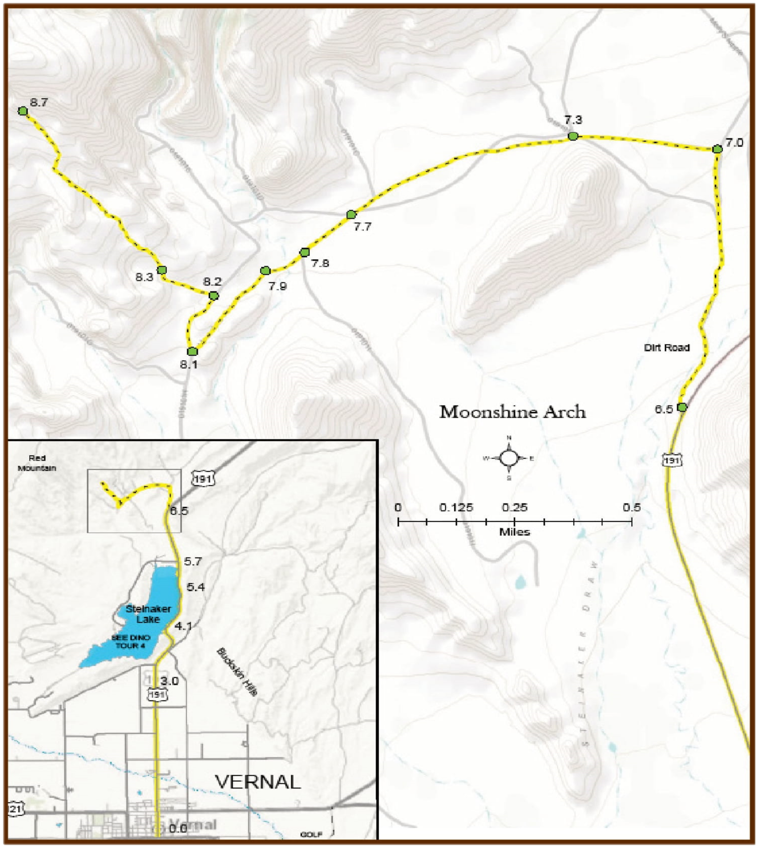
Moonshine Arch
Moonshine Arch is one of Vernal’s best kept secrets and is only 8 miles outside of town. This massive arch is about 85 feet in length and about 40 feet above the ground. You can access the Arch by jeep, atv, or hiking. Moonshine Arch is not a wellknown site, so there are no fences, railings or improvements. The trail is clearly marked, however, and there are green metal signs that lead you in the right direction. You might think you have taken the wrong path because you won’t see Moonshine Arch until you come around the last bend on the trail. Be prepared though, because you will be amazed and impressed at the site you see.
Pack a lunch, bring plenty of water in warmer weather, and get ready to take some amazing pictures. The Arch makes a perfect frame for taking pictures of Steinaker Reservoir and scenery in the area. Behind the arch are caverns where you can sit in the shade and eat or go exploring.

Mileage
0.0 Leaves Vernal north on US 191 from the center of town.
3.0 Looking north you can see the back side of Steinaker Dam, the first unit of the Central Utah Project.
4.1 Overlook of Steinaker Lake. This reservoir is the main feature of the Vernal Unit of the Central Utah Project, a
part of the Colorado River Storage Project. The reservoir has a storage capacity of 38,000-acre feet. Permanent storage of 5,000-acre feet of water is maintained for fish and wildlife. The reservoir offers good bass and trout fishing and is a favorite place for local boating and waterskiing enthusiasts. The State Park includes a swimming beach, boat ramp, picnic, and camping facilities. The Uintah Water Conservancy District delivers water to Ashley Valley for irrigation and municipal use. The hillside running parallel to the highway here is the Morrison Formation where dinosaur bones and gastroliths, gizzard stones of dinosaurs, are found.
5.4 Flaming Gorge-Uintas Scenic Byway Site and Nature Trail interpreting the wildlife of Steinaker State Park.
5.7 Entrance road to Steinaker State Park (left). DO NOT TURN HERE – Keep traveling on US 191.
6.5 Less than one mile past the entrance to Steinaker State Park, about the mid-point in the curve of the highway there will be a dirt road to the left, which is a little hard to see from the highway. Turn left onto this road which is also covered in gravel.
7.0 The gravel road crosses a small wash. About one-half mile from the highway turn left from the gravel onto a wide dirt road, then follow the green metal moonshine arch signs.
7.3 Tour veers left. To the right is where you can ride the Red Mountain OHV Trail. It is open to ATVs, Jeeps, Rock Crawlers, etc. The main trailhead is located at Doc’s Beach.
7.7 At the green metal sign, stay left.
7.8 Here you will come upon a fence line followed by a gulch. If you are not driving a high clearance vehicle, park off to the side and you can hike the rest of the way (about 1 mile).
7.9 Tour turns left. If you come to the mouth of a deep canyon beneath an alluring cliff filled with large shallow caverns, you have gone the wrong way and need to turn around.
8.1 Turn right and follow the dirt road through a sagebrush channel.
8.2 Tour stays to the left.
8.3 At this point on the tour you have the option to park your vehicle and walk towards the trail. It is located directly north in the uphill direction. If you are driving a jeep or ATV you are able to maneuver over a few technical spots and drive to the base of the arch.
8.7 Once you have made your way up the low ridge to the North and have turned the last corner, your breath will be taken away by the beautiful sandstone arch you will see. The tour ends here and returns to Vernal over the same route; however, upon reaching US 191 on the return trip, you can turn north (left) and take the Red Fleet, Flaming Gorge, or Red Cloud Loop tours.
