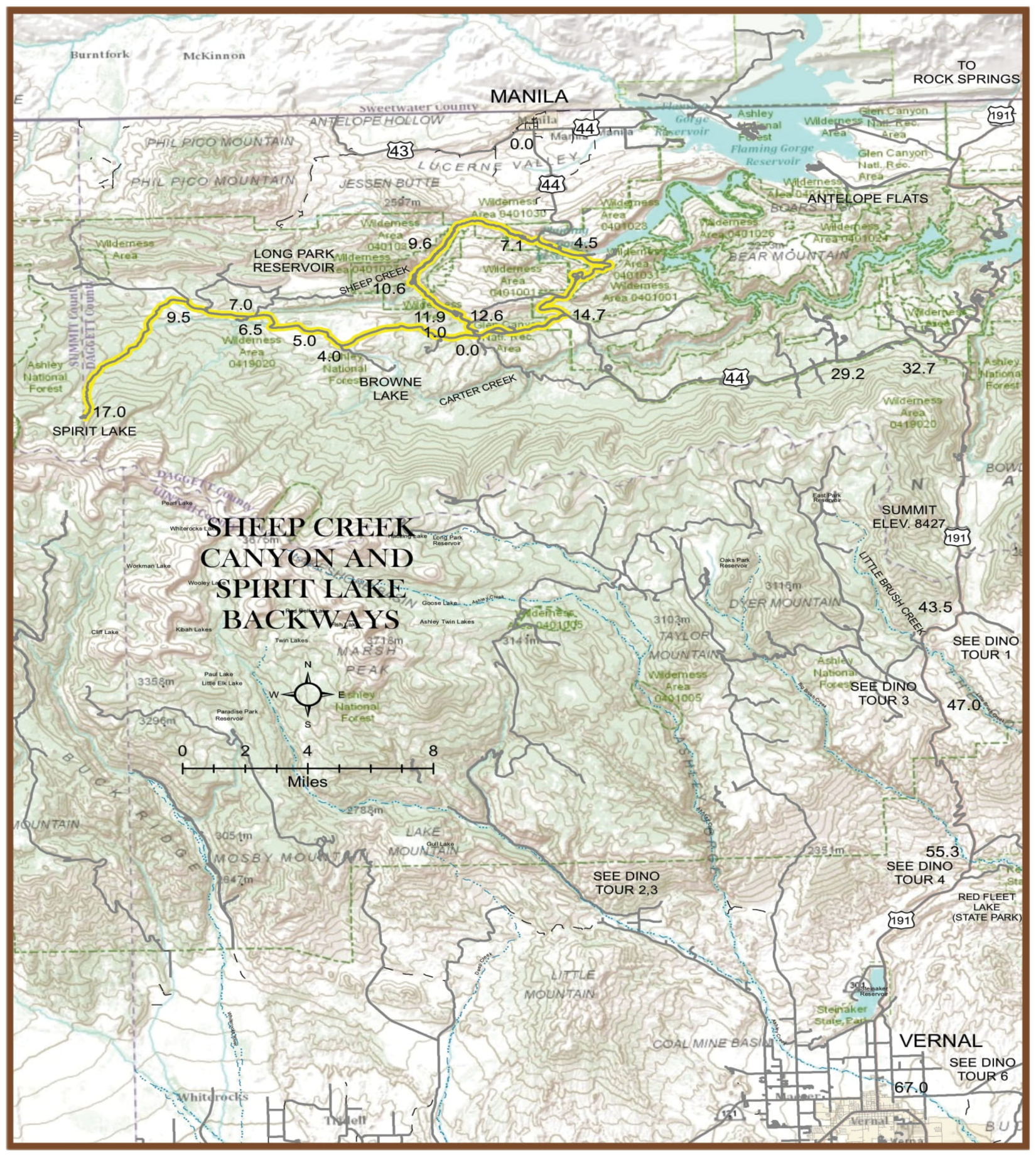
Sheep Creek Canyon & Spirit Lake Scenic Backways
Sheep Creek Loop Scenic Backway
This route was designated a State of Utah Scenic Backway in December of 1990. The northern end of the loop begins 4.6 miles south of Manila on Highway 44 (Flaming Gorge/Uintas Scenic Byway) at Sheep Creek Gap and Forest Service Road #218. The southern end of the loop begins at the Dowds Hole Scenic Byway Site located at the Junction of Highway 44 (Flaming Gorge/Uintas Scenic Byway) and Forest Service Road #218. This southern terminus is located 15.6 miles west of the junction of Highways 191 and 44.
The Backway is a 10-mile-long loop and is mostly paved. Short sections in the canyon have been graveled due to road deterioration.
This Backway travels through a spectacular canyon designated as a
geological area by the U.S. Forest Service on May 13, 1962. The canyon is one of the few places in the world where tourists can cover millions of years in only 20 minutes of driving.
An immense earth structure, the Uinta Crest fault, extends in a generally east-west direction through the center of this area. On the south
side of the fault the earth’s crust has been raised upward over 15,000
feet. Subsequent erosion has greatly reduced the upturned sedimentary strata north of the fault. Several of these formations are now clearly
exposed within the geological area. Younger formations are progressively exposed as one travels from south to north through the canyon.
Spirit Lake Scenic Backway
The State of Utah also designated this route as a Scenic Backway in December of 1990. This Backway begins at the junction of Sheep Creek Scenic Backway and Forest Road #221, 2.5 miles west of Highway 44.
The Backway is 17 miles long on graveled and dirt road surfaces, terminating at Spirit Lake on the northeastern end of the High Uintas Wilderness. Returning from Spirit Lake requires backtracking to the Sheep Creek Backway. Thus, the total driving distance is 34 miles.
This Backway travels through conifer-covered slopes and large open meadows, crossing over numerous streams, with the High Uinta Mountains as the backdrop. Leidy Peak is the most prominent landmark along the mountain ridge line that forms the background for this Backway.
Spirit Lake and the adjacent campground and lodge are located at the terminus of the Backway in a magnificent alpine setting. The HighUintas Wilderness Tamarack Lake Trailhead is located near the lodge. The lodge is the center of a backcountry resort operation under a permit by the Ashley National Forest. Fishing at Spirit Lake, day hikes, horseback riding, and wilderness backpacking trips are some of the local’s favorite activities.

Mileage – Sheep Creek Loop Scenic Backway
0.0 Start from the junction of Highways 43 and 44 in Manila, Utah.
4.6 Sheep Creek Scenic Byway site at Junction of Highway 44 and Forest Road #218. Nature trail and interpretive signs, describing wildlife of the area, including songbirds and kokanee salmon fish.
4.7 Navajo Cliff Picnic Area, next to Sheep Creek and beautiful Navajo sandstone cliffs.
7.1 Dowd’s Grave. Gravesite of the early settler, Cleophus Dowd.
8.1 Tower Rock-a chimney rock formation from the Weber sandstone layer towers over the road.
8.6 Big Springs and Sheep Creek Cave. The cave is available for exploring upon approval of the Forest Service. Call 435-789-1181 or 435-784-3445.
9.6 Palisades Memorial Picnic Grounds. Memorial site for campers killed in the 1966 flash flood in the canyon.
10.6 Geological loop pullout and overlook. View of Uinta Crest fault. View of window rock hole, cut in the rock formation by wind erosion.
11.9 Junction with Spirit Lake Scenic Backway (Forest Road #221).
12.6 Summit Springs Guard Station, built in the early 1930s.
14.6 Dowds Hole Scenic Byway Site, signs describing the wildlife of the area and the High Uinta Mountains.
14.7 Junction with Highway 44 (Flaming Gorge/Uintas Scenic Byway). Left turn to Manila; right turn to Flaming Gorge Dam or Vernal.
Those traveling from the Vernal area or from Flaming Gorge Dam who do not wish to go to Manila should access the Backway from the junction listed above as milepost 14.7. Distances between the attractions will be shown above but in reverse order.
Mileage – Spirit Lake Scenic Backway
0.0 Junction of Sheep Creek Loop Scenic Backway and Forest Road #221. View of Leidy Peak in the background.
1.0 Junction with the road to Ute Lookout Tower, a fire lookout built by the Civilian Conservation Corps in the 1930s. It is 0.7 miles from this junction to the tower; visitors are welcome. A trail to Browne Lake starts at the lookout.
4.0 Junction with Browne Lake Road. It is 1.75 miles from this junction to the lake…camping, fishing, and hiking activities. The trailheads to Red Lake, Teepee Lake, and Young Springs Park are also located in the Browne Lake area.
5.0 Junction with Sheep Creek Lake Road. It is 0.4 miles to the lake…camping, fishing, and wildlife viewing activities.
6.5 Carter Military Road crossing. The road was built in 1881 for transporting supplies from Ft. Bridger, Wyoming, to Ft. Thornburg near the present-day community of Vernal. Cement posts mark the road track.
7.0 Junction with the Long Park Reservoir Road. It is 1.8 miles to the reservoir…camping, fishing, and wildlife viewing activities.
9.5 Junction of Forest Roads #221 and #001. Road #001 goes on to Spirit Lake; Road #221 heads north toward Mountain View, Wyoming.
10.1 Junction with Hickerson Park Trailhead.
10.5 Junction with Sheep Creek Trailhead.
10.5-17.0 Backway follows the Middle Fork of Sheep Creek through conifer stands and small meadow areas.
17.0 Spirit Lake area…campground, lodge, restaurant, cabins, fishing, hiking, horseback riding activities. Trailheads for Jessen, Tamarack, Lost Lakes, and the High Uintas Wilderness.
