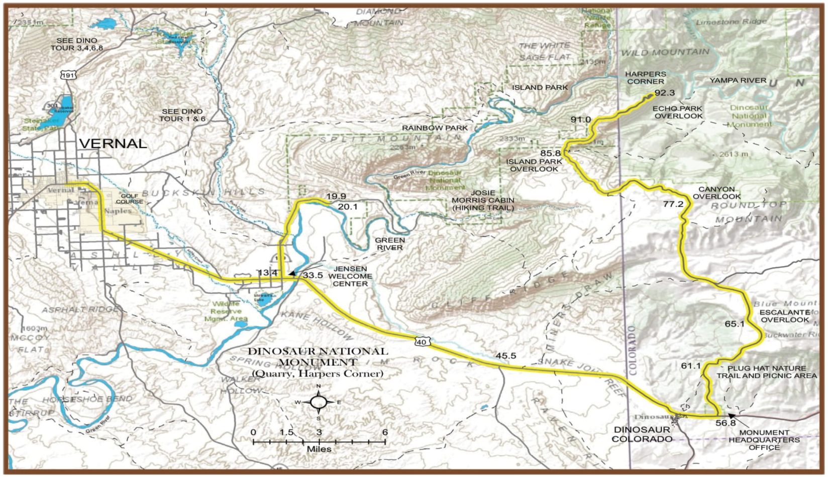
Dinosaur National Monument
Dinosaur National Monument takes its name from a remarkable deposit of fossil bones in the southwestern corner of the area. Fossilized bones of crocodiles, turtles, and 10 species of dinosaurs have been brought to view by excavating river sediment in the 150 million-year-old Morrison Formation.
Most of the Monument land lies northeast of the quarry where more than just fossils await your discovery. The Green and Yampa Rivers are master tools of erosion in a rugged canyon wilderness, providing majestic views along the Journey Through Time autoroute. Some of the best examples of Fremont Culture petroglyphs are easily accessible along the Tour of the Tilted Rocks autoroute. Historic home sites provide a glimpse into the rugged lifestyle of those who settled in this area.
Dinosaur National Monument is an area of rich history: paleontological, exploration, Native American, outlaw, and natural history that marks it as one of America’s last inaccessible regions-a romantic place where the Old West stayed young.
Total travel time: 4 1/2 hours. Fossil Area visit: 1 hour. Harper’s Corner Trail: 1 hour. Picnic lunch: 1 hour.
Total: 7 1/2 hours.

Mileage
0 Leave Vernal east on Highway 40 from Vernal Ave. and Main intersection.
12.0 About a mile south of the highway is Stewart’s Waterfowl Refuge, Utah Department of Fish & Wildlife Resources.
12.4 Entering Jensen.
13.4 Junction-turn left on U149 to Dinosaur National Monument. At this intersection, you will find a State Welcome Center and a rest stop.
15.7 Split Mountain Gorge can be seen on the right–this is where the Green River emerges from the canyon area into the Ashley Valley
17.8 Entering Dinosaur National Monument. The road follows along the bank of the Green River at this point.
19.7 Entrance station (entrance fee charged during the busy months) and junction-turn left to stop at the visitor center.
19.9 Parking area-The visitor center contains a fine bookstore, exhibits explaining the fossils, petroglyphs, and other park features, and information about how to see fossils in the park. The Carnegie Quarry (also called the Douglass Quarry) is one of the best Jurassic Period dinosaurs found in the world. Between 1909 and 1924, Paleontologist, Earl Douglass, discovered 10 species of dinosaurs, twenty complete skeletons, which are displayed in museums throughout the country, and rare juvenile dinosaur skeletons and skulls. The Carnegie Quarry and other fossil quarries in the park have greatly advanced the study of dinosaurs. Current research in the park is focused on understanding the ecosystems the dinosaurs lived in, which has resulted in the discovery of new species of dinosaurs, salamanders, frogs, lizards, mammals, and plants. By protecting fossils we can better understand the past. By understanding the past we can better understand the present.
20.1 Junction-turn left to begin a self-guided auto Tour of the Tilted Rocks (guide booklets can be obtained from the bookstore or a pamphlet box beside the road). Tour takes about 1 1/2 hours. Discover Indian rock art, geology, wildlife, and historic ranches. Scenic views of Split Mountain, the Green River, and Cub Creek await you. The Desert Voices Nature Trail has wayside signs for adults and children. Cool, green box canyons entice hikers at the end of the drive. Return to US 40 or Jensen.
33.5 Turn left on US 40 to continue the tour to Harper’s Corner and scenic drive through Dinosaur National Monument. The town of Jensen was settled in the mid-1800s, and some of the original log cabins of the early settlers are still visible.
34.1 Green River Crossing.
40.7 Musket Shot Springs. Turnout-marker telling of the expedition made by Father Dominguez and Father Escalante in September of 1776. They were the first known white men to come through this part of the country. Cockleburr Flat-face of Blue Mountain to the left-graphic view of the upheaval of the earth’s crust visible on the face of the cliffs. Winter sheep range-arid desert country grows only sparse grasses and sagebrush on which sheep forage during the winter.
51.6 Entering Colorado
54.4 Entering Dinosaur, Colorado. Continue on Highway 40 through Dinosaur (the last place for gas, water, etc.) to Monument Headquarters before going into the mountain area.
56.8 Junction-turn left at the Canyon Area sign to enter the visitor center and begin the Harper’s Corner Road self-guided auto tour. The Canyon Area Visitor Center has exhibits and a ten-minute audio-visual program that will orient you to the Colorado side of the park. Beginning at the visitor center is the Cold Desert Nature Trail. This half-mile-long, walk will introduce you to the desert shrub community and its wildlife. From the visitor center parking lot turn right onto Harper’s Corner Road to begin the 31-mile (one-way) self-guided auto tour. Allow 2-4 hours to take this drive. You can obtain the auto tour guide at the visitor center bookstore or from a pamphlet box beside the road at the beginning of the drive. The Harper’s Corner Road auto tour will introduce you to the varied geology and biological diversity of Dinosaur.
61.1 Plug Hat Nature Trail and picnic area. Parking for the nature trail is on the right. The trail is quiet, short, and an easy walk-a place where you can discover the pinon and juniper forest community. Pinon and juniper forests cover a vast number of acres in Utah and Colorado. Learn their importance to wildlife and to us. Across the road is the entrance to the picnic area and great views of Blue Mountain and the exposed colorful rock formations below.
77.2 Turnoff-Canyon Overlook, picnic area (one mile), and nature trail. The short and easy nature trail will take you to a spectacular view of Yampa Canyon. Along the way, you will discover the Douglas fir community perched on the heights of the mountain’s north slope.
81.0 Utah-Colorado state line.
84.8 Turnout–view of the Mitten Park Fault-forms the eastern escarpment of Harper’s Corner and crosses the northern end of Steamboat Rock. Displacement is from 1500-2000’.These dislocations in the earth’s crust were in response to the uplift of the Uintah Mountains millions of years ago. You can see the folded and faulted Moenkopi and Park City formations far below this level. They are younger and belong above the Weber Formation upon which you stand.
85.2 Junction–tour continues straight ahead on paved road (right to Echo Park Campground and Picnic Area). If you take the side trip to Echo Park, it’s advisable to check road conditions and weather (unimproved road).
85.8 Turn left to Scenic Overlook–gives a scenic view of Island park on the Green River far below. 87.4 Iron Springs Bench Overlook–gives a breathtaking look at Steamboat Rock, the Yampa River, the canyon, and it’s joining with the Green River and Echo Park.
90.9 Utah-Colorado state line.
91.0 Echo Park Overlook–spectacular view of Echo Park immediately below with the canyons of the Yampa River beyond. The colorful rock formations are well worth viewing.
92.3 End of the road; however, the trail takes you to Harper’s Corner (a must!). This affords a view of the Yampa and the Green River where they come together at Steamboat Rock, and you can also see the canyons running both directions of the Green River. Very spectacular, a sight to behold, out of this world!
161.5 End of tour.
